Connectiv is the world’s first modular LiDAR system for drone. Customize your sensor to optimize your projects.
What is a LiDAR sensor?
A LiDAR (Light Detection and Ranging) is an advanced remote sensing technology that uses laser pulses to measure distances with high precision, creating detailed 3D maps of the environment. Essential for industries like surveying, construction, and infrastructure inspection, LiDAR ensures accurate terrain modeling, vegetation analysis, and object detection. Connectiv is a modular LiDAR solution, allowing to customize your laser, INS, and camera configuration to provide unmatched precision and adaptability for drone-based mapping and geospatial data collection.
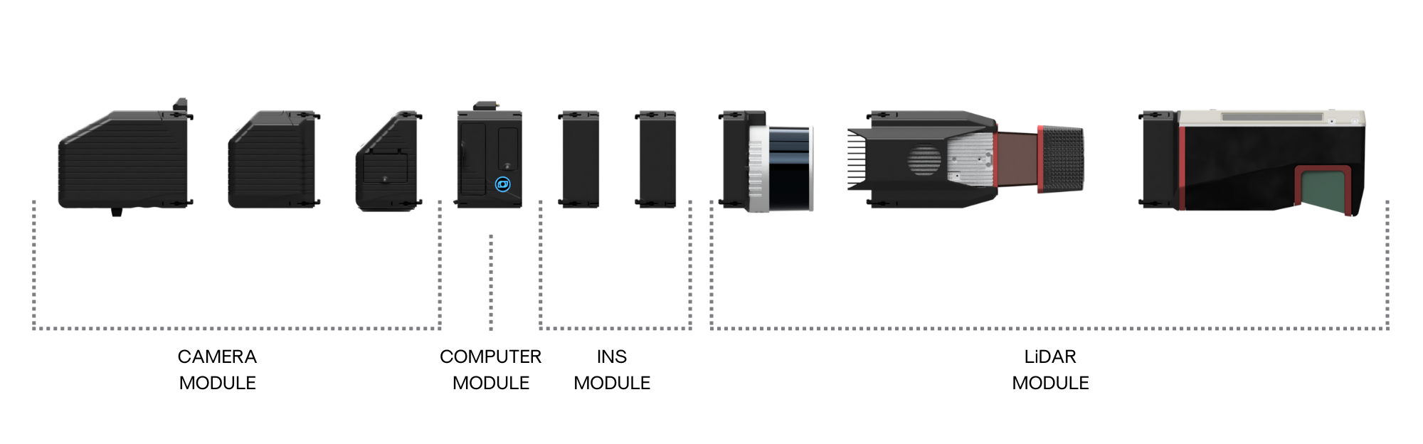
Connectiv: The Modular LiDAR Sensor
The second generation of Balko Tech’s lidar sensor, Connectiv, is fully modular. It allows the user to interchange lasers, inertial navigation systems (INS) and cameras in order to improve the performance required to meet the varied project requirements. With a single sensor, you can meet the requirements of several activity sectors and obtain a better return on investment! Its small, light, and easy-to-use housing has been completely redesigned to facilitate interchangeability between the different modules available and enable installation on small drones such as the DJI M300/350.
Benefits of a modular design
Connectiv features
- New e-Connect application allows to start remote recording and real-time viewing
- Reduction in total weight (500 g to 1 kg depending on configuration)
- Reduction in total dimensions (30 to 40% depending on configuration)
- Quick closing/opening system for modules (no screws)
- Quick close/open attachment support for installing lidar to drone
- Complete review of electronic and mechanical design
- Camera module completely integrated into the housing for better stability and robustness
- New integration of laser modules and INS
- New integration of multispectral and thermal cameras
New e-Connect Application for Remote Control
In addition to the Connectiv and the e-LAS software, Balko has developed a brand new application called e-CONNECT allowing the operator to start/stop the lidar remotely, monitor the data collection and status of components.The operator can have full confidence that the system is recording properly. On-board information is visualized in real-time from a tablet on the ground while the Connectiv takes off!
e-Connect
- Enable the operator to start/stop the lidar remotely from the ground while in-flight
- Monitor status of different components
- Ensures data is being captured correctly
For more details, visit the product page.
e-LAS Software for Fast and Accurate Data Processing
The e-LAS software combines performance, speed and ease of use! e-LAS aims to achieve the best possible relative and absolute accuracy with the selected sensor configuration! With its optimized algorithms, it offers unbeatable processing speed. In less than 5 minutes you will get your point cloud (LAS) calibrated, aligned, adjusted, colorized and georeferenced. Use the high performance of your INS to precisely geolocate aerial images to precisely geolocate aerial images prior to processing in user’s preferred photogrammetric software.
- New interface
- Ground control point import
- Optimized code for higher processing speed
- RMSE calculation and export of precision report*
- Adjustment on selected targets
*Available October 18, 2023.
For more details, visit the product page.