Key Takeaways
- BVLOS, introduced by Transport Canada, now allows drones to fly beyond the line of sight, over hundreds of kilometers.
- This evolution transforms drones into national geospatial data acquisition platforms, where flights were previously limited.
- The convergence of LiDAR, photogrammetry, multispectral and RTX corrections enables centimeter-level accuracy without a local reference station.
- Drones and satellites become complementary: broad satellite coverage to identify areas of interest, targeted BVLOS drone missions to capture detail.
New horizons thanks to Canadian regulations
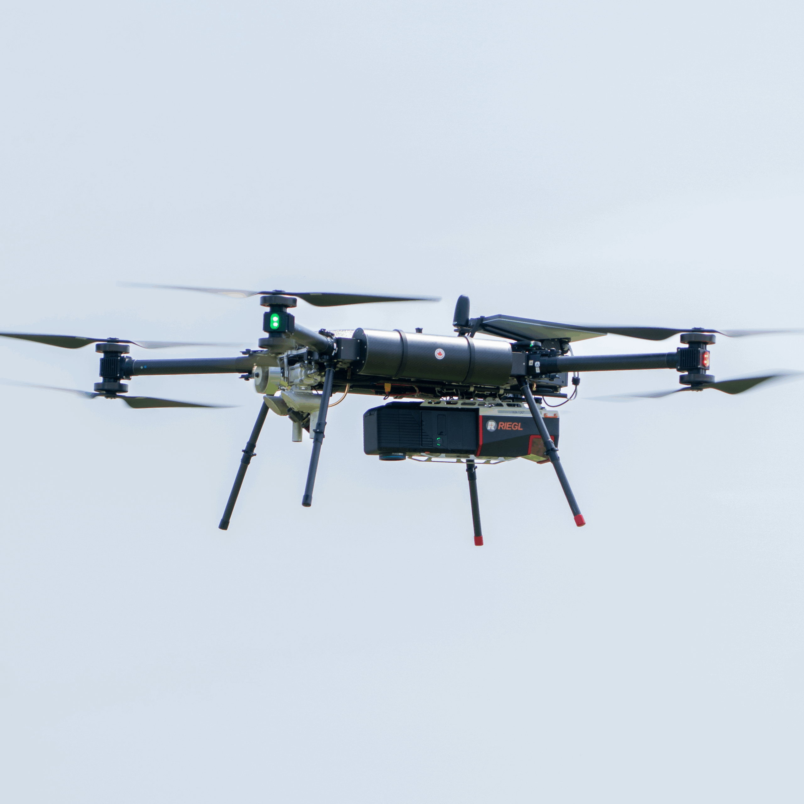
Recent changes in Canadian drone regulations mark a pivotal moment for geospatial data capture. The introduction of Beyond Visual Line of Sight (BVLOS) operations by Transport Canada now allows drones to fly farther, longer, and safer, transforming their role from localized survey tools to national-scale data acquisition platforms. Once constrained by strict line-of-sight limits, operators can now conduct extended missions that cover hundreds of kilometers, provided they meet the new safety and communication standards.
This evolution enables mapping and monitoring across remote and complex landscapes, from northern infrastructure corridors to vast agricultural and forestry zones, where access was once limited or prohibitively costly. BVLOS operations thus bridge the gap between traditional aerial surveys and satellite observation, expanding Canada’s capacity for continuous, high-resolution geospatial intelligence.
Technological convergence and sensor performance
The potential unlocked by regulation is amplified by rapid advances in sensor integration. Modern drone payloads combine LiDAR, high-resolution photogrammetry, multispectral imaging, and precision navigation within lightweight, energy-efficient configurations. This technological convergence replaces single-sensor missions with integrated systems capable of collecting diverse datasets in a single flight.
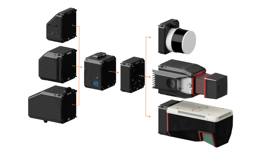
High-density LiDAR point clouds can now be precisely aligned with optical imagery through real-time RTX correction services, providing centimeter-level accuracy without reliance on local base stations. Unlike traditional RTK or PPK methods, RTX ensures reliable, global-scale positioning, crucial for BVLOS missions over remote territories. The resulting datasets are geometrically precise and semantically rich, capturing the structure, texture, and spectral characteristics of landscapes in unprecedented detail.
Lightweight, modular payloads also improve flight efficiency. Reduced sensor mass extends endurance and stability, enabling optimal flight parameters for wide-area coverage. For corridor mapping, environmental monitoring, or large-scale topographic modeling, these advances mean fewer flights, faster turnaround, and lower operational costs while maintaining exceptional accuracy.
Challenges solved through new technologies
The convergence of regulation and technology directly addresses long-standing obstacles in geospatial mapping:
- Coverage vs. resolution: Extended BVLOS range and high-precision sensors eliminate the trade-off between detailed imagery and large-area coverage.
- Access to remote or hazardous areas: Autonomous drones equipped with advanced navigation and obstacle-avoidance systems can safely collect data in environments inaccessible to manned aircraft.
- Temporal consistency: Frequent revisits make it possible to monitor dynamic phenomena (vegetation growth, urban expansion, or ice retreat) with near-real-time updates.
- Data interoperability: Multi-sensor integration produces harmonized datasets ready for direct use in GIS and remote-sensing workflows, supporting automated classification and change-detection analysis.
These capabilities enhance productivity and reliability across industries such as forestry, mining, agriculture, infrastructure, and disaster management, where timely, accurate information is vital.
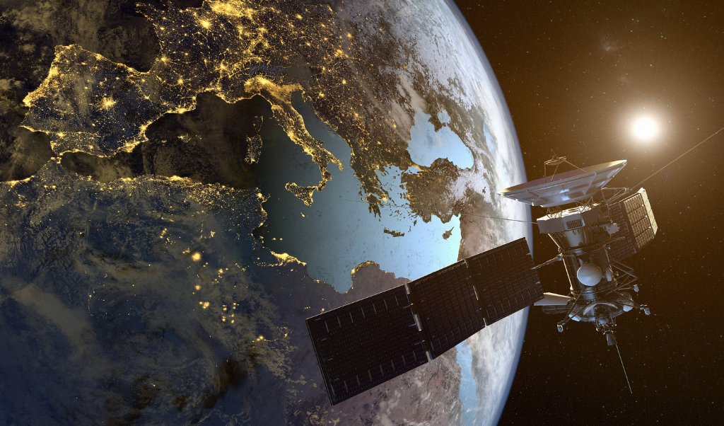
Integrating airborne and satellite perspectives
The next frontier lies in uniting drone-acquired and satellite-derived data. Drones provide unmatched spatial resolution and flexibility, while satellites deliver continuous, wide-area context. Together, they form a multi-scale mapping ecosystem. Satellite imagery can identify regions of interest, such as deforestation zones or flood areas, prompting targeted BVLOS drone missions for detailed assessment. Conversely, drone data can calibrate and validate satellite-based models, improving the precision of national or global datasets.
This synergy enables advanced analytics, including AI-driven modeling and predictive mapping, that combine temporal coverage with ground-truth accuracy. The result is a more complete, responsive view of environmental and infrastructure change.
Canada at the forefront
Canada stands at the forefront of a global transformation in geospatial intelligence. The alignment of progressive airspace regulation with rapid technological innovation is redefining how the Earth’s surface is mapped, modeled, and monitored. The convergence of lightweight, high-precision sensors and extended BVLOS drone operations offers a scalable and efficient approach to data acquisition, bridging the gap between satellite overview and on-the-ground detail.
As these systems mature, they promise to expand the capacity for precision, efficiency, and insight across all areas of geospatial science. The horizon of mapping is moving farther than ever before, and with it, the power to understand our changing world in unprecedented ways.
FAQ – Key Takeaways
BVLOS stands for “Beyond Visual Line of Sight” — operations where the drone flies outside the pilot’s field of vision. In Canada, these operations are regulated by Transport Canada.
RTX is a real-time positioning correction service offering centimeter-level accuracy on a global scale, without a local reference station. Unlike RTK and PPK, it remains reliable in remote territories.
Modern payloads integrate LiDAR, high-resolution photogrammetry, multispectral imaging and precision navigation in lightweight configurations. A single flight collects multiple datasets, reducing the number of missions required.
Satellites cover large areas and identify zones of interest (deforestation, flooding). BVLOS drones then take over for detailed monitoring. Conversely, drone data helps calibrate and validate satellite models.
Forestry, mining, agriculture, infrastructure and disaster management. All share a common need: accessing accurate data across vast areas or hard-to-reach environments.
Other news
News
20260522
Balko and ARA Robotics Announce a Strategic Partnership
Quebec, Canada — Balko and ARA Robotics announce the signing of a strategic partnership...