Key Takeaways
- e-LAS 3.0 is the new version of Balko’s LiDAR and imagery processing software.
- Redesigned interface and optimized default values to reduce the learning curve.
- New strip adjustment with XYZ correction: more precise alignment with ground control points.
- Automatic recalibration after module change: fewer manual steps, reduced risk of error.
Smarter, Faster, More Precise LiDAR and Imagery Processing
With this release, e-LAS 3.0 delivers significant improvements in usability, performance, and data quality. The focus is on streamlining workflows, reducing manual intervention, and producing reliable LiDAR and imagery results, even for large-scale and complex projects.
Developed to support Balko’s growing modular sensor ecosystem, e-LAS 3.0 addresses the higher precision and robustness required when swapping sensors in the field. The software now recovers factory-level calibration precision, improves strip alignment, and delivers sharper point cloud colorization. It also estimates precision and performs tie matching with full XYZ correction, strengthening alignment with ground control points, and overall geospatial reliability.
” With this new version, e-LAS maintain a constant set of original calibration values. It ensures stronger strip alignment and sharper, more accurate colorized point clouds. In addition, e-LAS now estimates precision and performs tie matching with full XYZ correction, significantly improving alignment with ground control points and overall geospatial reliability, ” says Fengman Jia, Senior Geomatics Professional.
Below is an overview of the key improvements in e-LAS 3.0.
Redesigned Interface for Efficient Workflows
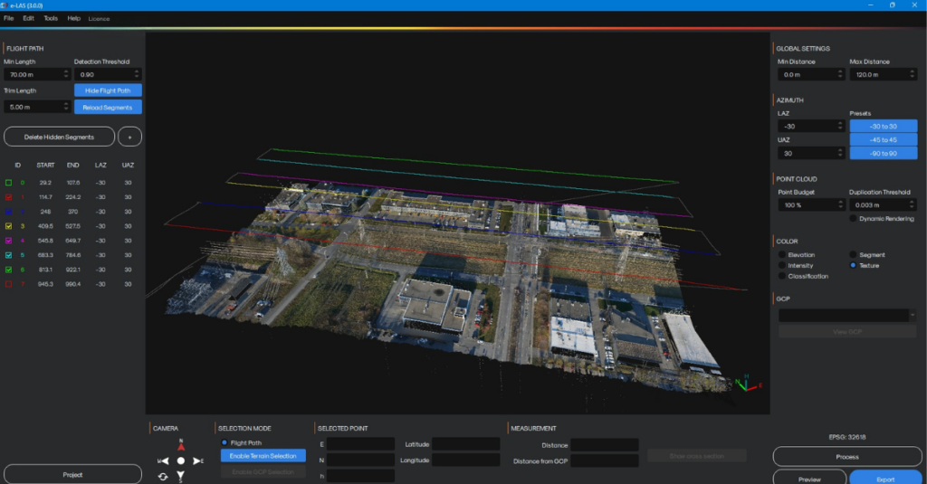
The e-LAS interface has been redesigned to reduce the learning curve while preserving advanced capabilities. Core tools and essential pages remain immediately accessible, while advanced parameters are placed in optional menus. This approach keeps workflows clear without limiting control.
We optimized default parameter values to deliver reliable results in most scenarios and only require adjustment for uncommon or specialized projects. This design allows users to focus on their data rather than software configuration.
Navigation within 3D scenes is smoother, supported by predefined multi-axis camera views and an integrated North and East compass. Performance optimizations ensure fluid interaction, even with dense point clouds and very large datasets.
Advanced Visualization and Analysis Tools
e-LAS 3.0 strengthens visualization and validation directly within the processing environment. The improved cross-section tool enables profile generation and integrated measurements for faster analysis.
Ground Control Points are easier to manage. GCP identifiers are displayed directly in the point cloud, and selecting a point reveals its X, Y, and Z coordinates instantly. This simplifies quality control and validation.
New point cloud colorization options enhance data interpretation across different project types and analysis needs.
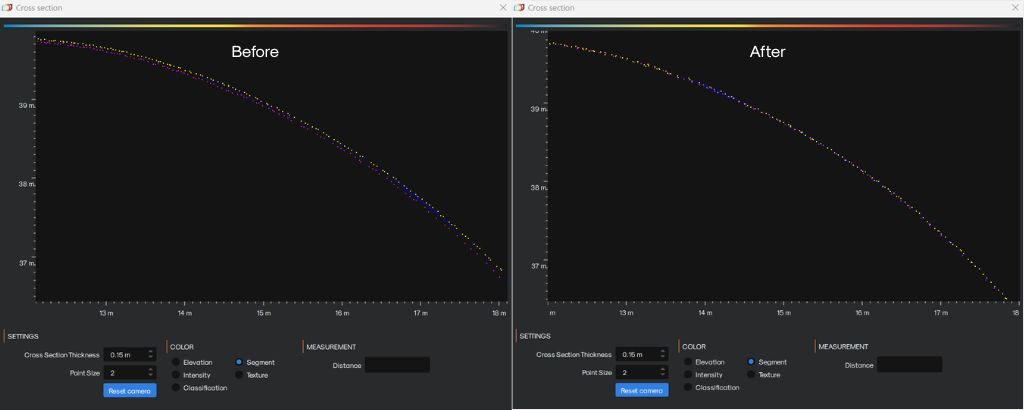
Enhanced LiDAR Accuracy and Strip Line Adjustment
At the heart of e-LAS 3.0 is a new advanced LiDAR strip adjustment and alignment algorithm optimized for relative accuracy beyond industry standards. Designed for complex datasets, it improves inter-strip consistency and reduces residual offsets.
The algorithm supports direct processing from LAS files using trajectory data, increasing workflow flexibility. Tie matching has also been improved with a planimetric X,Y correction in addition to the altimetric Z correction, already present in the previous version.
New recalibration options using control points along the X, Y, and Z axes, combined with improved georeferencing at export, ensure consistent and reliable deliverables.
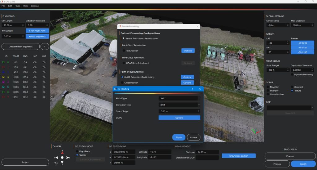
Automated and Scalable Processing Workflows
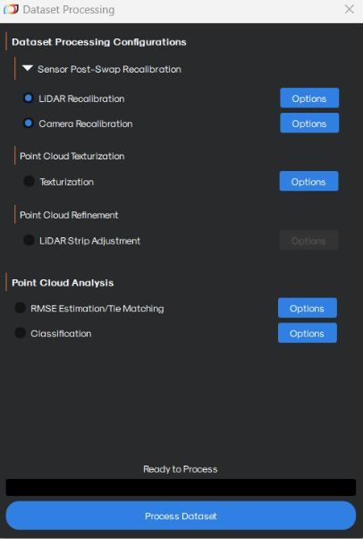
e-LAS 3.0 introduces automation aligned with real-world operations. Automatic recalibration after LiDAR or camera module changes reduces manual steps and minimizes the risk of errors.
It is now possible to perform processing and adjustment directly from LAS files with flexible export options. Data can be delivered as individual LiDAR strips or as a consolidated project, depending on production needs.
The workflow was refined through close collaboration between algorithm developers and software engineers, ensuring advanced processing capabilities remain intuitive and practical for users.
“Transforming advanced algorithms into a clear and usable workflow was an iterative, highly collaborative process. While the technical direction was clear from the start, the challenge was determining how much control to expose without overwhelming users. Early development involved close collaboration between the research team specializing in geomatics algorithm development and software developers to stabilize and validate the algorithms. As the workflow matured, a larger group worked in continuous feedback loops to refine parameters, interface logic, and processing steps. This approach ensured that powerful capabilities were delivered through a practical and intuitive workflow,” says Mathieu Poulin, Software Team Lead.
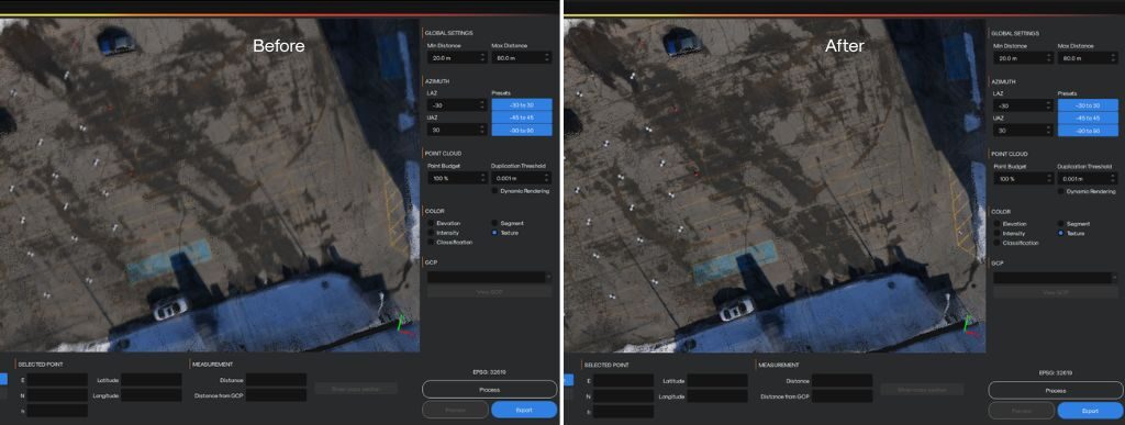
Improved Imagery and Point Cloud Colorization
Imagery quality is critical for accurate point cloud visualization. e-LAS 3.0 introduces a new deblurring algorithm that improves image sharpness and recovers usable detail from challenging datasets.
Point cloud colorization derived from imagery is more consistent and visually accurate. The same dataset processed with e-LAS 3.0 delivers clearer textures and improved visual quality.
The Team Behind e-LAS 3.0
e-LAS 3.0 is the result of a tightly coordinated effort between geomatics specialists, algorithm researchers, and software engineers working toward a shared objective: delivering higher precision, stronger automation, and a smoother user experience.
From the earliest stages, algorithm development and software integration evolved side by side. Enhancements were continuously tested, refined, and adapted to ensure both technical robustness and practical usability. Each innovation informed the next, creating a development cycle driven by constant feedback and collaboration.
Supporting these algorithmic improvements required significant architectural evolution. Data management strategies were redesigned to handle extremely large datasets efficiently, core algorithms were re-optimized, and specialized tools such as in-house nearest-neighbor processing and MTA zone integration were implemented. These backend advancements were developed in close alignment with processing requirements, ensuring performance gains translated directly into real-world workflow improvements.
Throughout the process, the team worked iteratively, balancing technical depth with user clarity. Decisions about parameter exposure, automation levels, and interface structure were made collectively, with continuous back-and-forth between research and engineering. This synergy ensured that powerful processing capabilities were not only advanced, but also intuitive, scalable, and ready for real operational environments.
A Meaningful Step Forward
This update is not about isolated features. It is about how everything works together.
A cleaner interface, stronger automation, more robust algorithms, and improved imagery combine to create a more efficient and reliable processing experience. Whether you are validating accuracy, managing large projects, or delivering high-quality geospatial products, e-LAS 3.0 is designed to help you work faster and with greater confidence in your results.
FAQ – Key Takeaways
e-LAS is Balko’s processing software for LiDAR and imagery data collected by its drone-mounted sensors. It handles strip adjustment, point cloud colorization, ground control points, and geospatial deliverable export.
e-LAS 3.0 adds planar X, Y correction to tie matching, in addition to the altimetric Z correction already present. This three-axis correction strengthens point correspondence in complex or repetitive environments and improves alignment with ground control points.
The automatic recalibration in e-LAS 3.0 activates after a LiDAR sensor or camera change on Balko’s modular system. It replaces the manual steps previously required, reducing preparation time and minimizing the risk of error between missions.
Yes. e-LAS 3.0 allows processing and adjustment directly from LAS files, provided the associated trajectory data is available. Deliverables can then be exported by individual strip or as a consolidated project.
e-LAS 3.0 integrates a new automatic image correlation algorithm that recovers geometric details and improves colorization sharpness. The result: sharper textures, more homogeneous tones, and a rendering more faithful to real-world terrain.
Other news
News
20260522
Balko and ARA Robotics Announce a Strategic Partnership
Quebec, Canada — Balko and ARA Robotics announce the signing of a strategic partnership...