Key Takeaways
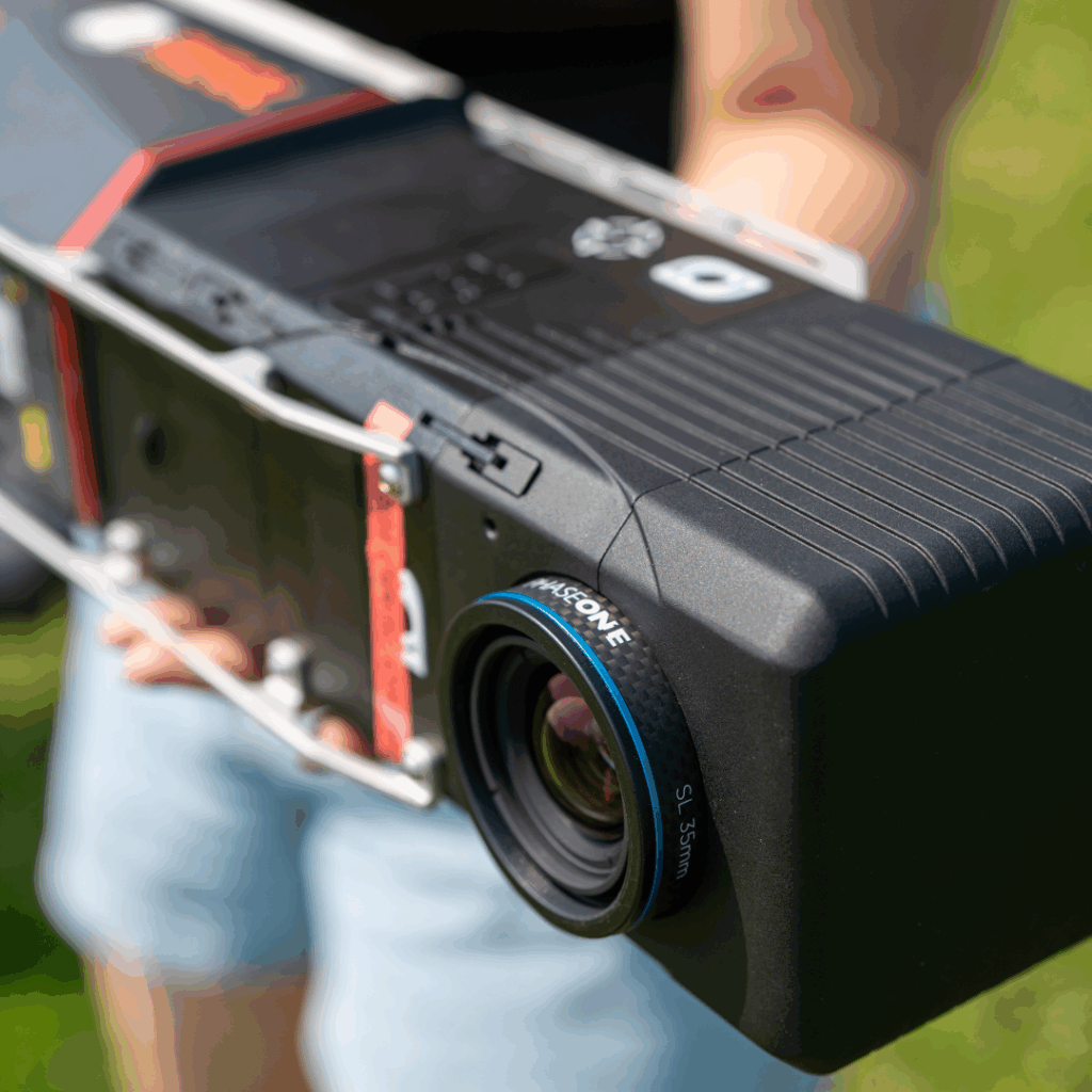
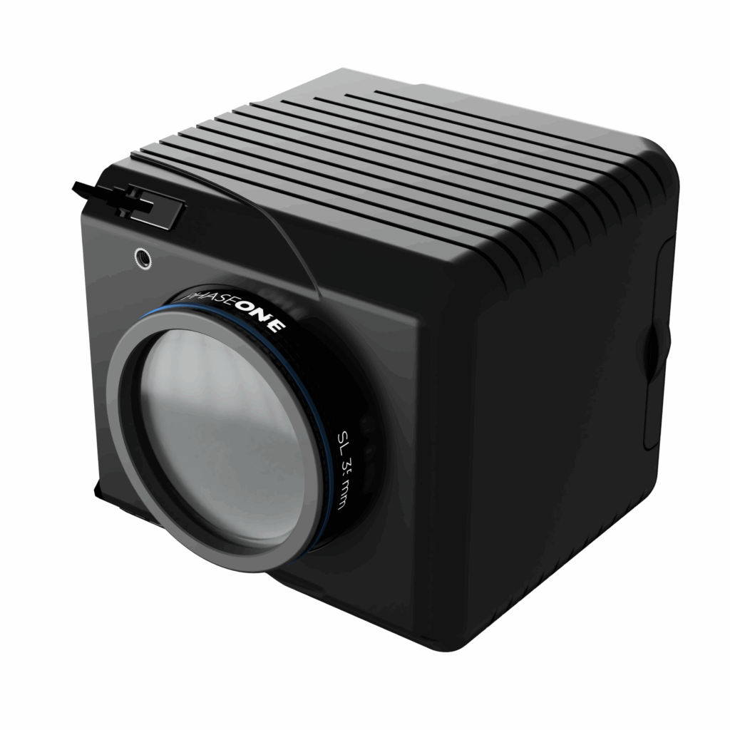
- Balko adds the 128 MP RGB camera module (Phase One P5 UAV) to the Connectiv modular ecosystem for ultra-high-resolution aerial imaging.
- 128 MP medium format sensor and wide field of view: fewer flight lines, more area covered per mission.
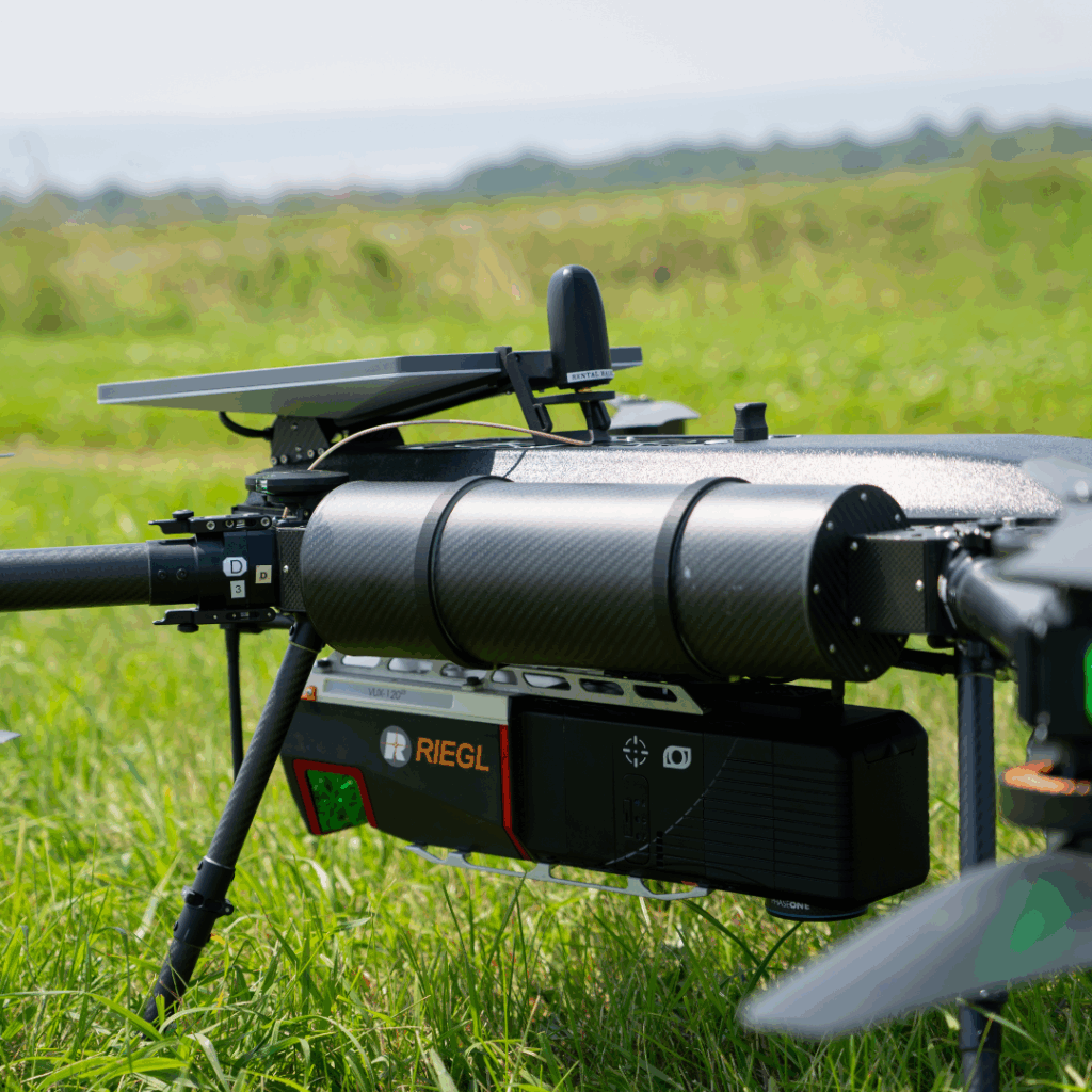
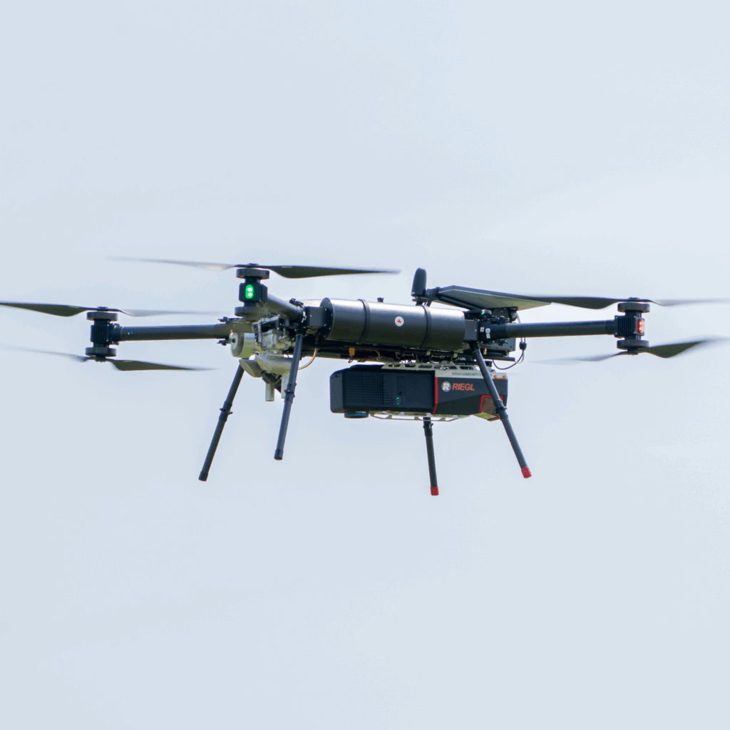
- Combined with LiDAR and INS modules, it generates colorized, photorealistic point clouds with precise georeferencing.
- With the VUX-120 LiDAR, missions can be completed up to 15 times faster — ideal for large-scale surveys.
Elevating imaging capabilities in aerial surveying
Balko is expanding its Connectiv offering with the integration of the RGB 128 MP camera module. This new option provides surveyors and geospatial professionals with a powerful tool to generate ultra-high-resolution imagery while maintaining the flexibility of the Connectiv system. Fully compatible with existing hardware and software, the RGB 128 MP brings new configurations and capabilities to organizations seeking efficiency and precision in data collection.
Phase One technology for unmatched image quality
At the core of the RGB 128 MP is the Phase One P5 UAV 35 mm camera, a benchmark in aerial imaging. Its 128-megapixel medium-format sensor delivers millimetric pixel size images with a lens resolution of 13,468 × 9,564 per pixel, ensuring that even the smallest features are captured with survey-grade precision.
This 35 mm lens field of view of 66° on the long side and 49° on the short side allows each image to cover a wide swath of terrain, reducing the number of flight lines required for complete coverage. This directly improves operational efficiency, enabling users to survey larger areas in fewer flights and with lower costs.
The combination of the RGB 128 MP’s high resolution, wide field of view, and an impressive up to 1/16,000 sec shutter speed enables operators to fly both higher and faster while maintaining survey-grade image quality. For example, with this high-resolution inspection module, flights at 250 m AGL and speeds of up to 100 km/h still deliver a ground sample distance (GSD) of 2.46 cm with motion blur under 5 mm. This capability significantly increases productivity by reducing flight times and maximizing coverage, all while ensuring that image sharpness and detail remain uncompromised.
A dynamic range of 80 dB ensures that both highlights and shadows are recorded faithfully, which is especially critical in challenging conditions such as urban corridors, steep terrain, or forested environments. The minimum focusing range of 60 m to infinity guarantees sharp, distortion-free images across typical UAV altitudes, providing consistency and reliability in data capture.
Hardware integration: unlocking new configurations with LiDAR and INS modules
The strength of the RGB 128 MP lies not only in its image quality but also in how seamlessly it integrates into the Connectiv hardware ecosystem. Combined with Balko’s LiDAR modules and high-precision INS, it enables powerful hybrid payloads. For instance:
- RGB + LiDAR: Generate photorealistic, colorized point clouds where the high-resolution imagery enriches the LiDAR data with true color context. This is particularly valuable for urban mapping, forestry, and mining.
- RGB + INS: Achieve highly accurate georeferencing of imagery, ensuring consistent alignment even in GPS-challenged environments.
- Full configuration (RGB + LiDAR + INS): Create complete 3D datasets where every point in the LiDAR cloud is colorized and precisely positioned, supporting advanced modeling and digital twin applications.
The VUX-120 LiDAR module is a natural match for the RGB 128 MP camera module, as both are engineered for high-altitude, high-speed operations. In this configuration, missions can be flown three times higher and five times faster compared to other configurations. This results in projects being completed up to 15 times faster, making it an ideal solution for large-scale surveys where time and efficiency are critical. By combining dense LiDAR data with ultra-high-resolution imagery, users can generate colorized point clouds and detailed 3D datasets at unprecedented speed, without compromising accuracy or detail.
Connectiv allows you to tailor your payload to project needs, whether they require detailed visual documentation, precise topography, or a combination of both.
Streamlined workflows with Connectiv software
The integration of the RGB 128 MP extends to the Balko software environment, where imagery is automatically processed and aligned with LiDAR and INS outputs. The system ensures fast and reliable dataset synchronization, eliminating the need for time-consuming manual steps or third-party software.
With this unified workflow, users can seamlessly move from data collection to analysis, generating orthophotos, textured 3D models, and georeferenced point clouds in less time. This integration minimizes complexity and empowers teams to deliver accurate, professional results faster.
Transforming workflows across industries
The integration of the RGB 128 MP into the Connectiv ecosystem creates tangible benefits for a wide range of industries, where technical specifications translate into clear operational advantages.
- Powerline and pipeline inspection: The millimetric precision allows detection of the smallest anomalies, such as cracks, corrosion, or structural stress, without sending inspectors into hazardous environments. Consistent flight lines from UAVs provide perfectly aligned imagery from repeated missions. This makes it easy to compare datasets over time and quickly spot even subtle changes. This capability is invaluable for utilities and energy companies seeking to maintain infrastructure integrity and prevent costly failures.
- Surveying and mapping: The high resolution and FOV allow surveyors to cover larger areas with fewer flight lines while still achieving centimeter-level precision. This efficiency is ideal for cadastral mapping, corridor mapping for transportation projects, and construction site monitoring, where time and cost savings are critical.
- Forestry and environmental monitoring: The camera’s dynamic range ensures that shaded forest canopies and sunlit clearings are both captured with clarity. Combined with LiDAR, this enables detailed analysis of canopy structure, biomass estimation, and long-term environmental monitoring, even in challenging lighting conditions.
- Mining and quarrying: The wide field of view reduces the number of UAV passes needed to document excavation sites, while the minimum focusing range of 60 m to infinity ensures sharp imagery across large open pits. This enables the generation of precise volumetric models, performing change detection, and creating accurate visual records of extraction areas.
- Urban planning and asset inspection: High-resolution and broad dynamic range allow professionals to capture complex environments with both bright reflective surfaces and shaded areas, common in urban corridors. This ensures reliable datasets for building inspections, infrastructure monitoring, and the creation of accurate 3D digital twins.
By bridging the gap between visual imagery and geospatial measurement, the RGB 128 MP adds even more versatility to Connectiv, enabling professionals to push the limits of what’s possible in aerial surveying.
FAQ – Key Takeaways
At the heart of the 128 MP RGB module is the Phase One P5 UAV 35 mm camera, a reference in aerial imaging. Its 128-megapixel medium format sensor delivers images at a resolution of 13,468 × 9,564 pixels.
At 250 m AGL and a speed of 100 km/h, the 128 MP RGB module delivers a ground sample distance of 2.46 cm, with motion blur under 5 mm.
The 128 MP RGB camera module can be configured with various LiDAR options for colorized point clouds, and with an INS module for precise image georeferencing. The 128 MP RGB + LiDAR + INS configuration produces complete 3D datasets.
Both modules are designed for high-altitude, high-speed operations. Combined, they enable missions three times higher and five times faster, completing projects up to 15 times more quickly.
Power line and pipeline inspection, surveying and mapping, forestry and environmental monitoring, mining, as well as urban planning and asset inspection. Millimeter-level precision and a wide field of view address each sector’s specific needs.
Other news
Éducation
29 July 2026
Technological sovereignty
Discover why technological sovereignty influences the choice of geospatial solutions in...